Tuesday, 11 July 2017

Upper Farmers Rapids: What a difference two days makes!

Last week I went out to Upper Farmers Rapids (Gatineau River) on July 3rd and 5th, and found very different levels.
July 3rd
July 5th

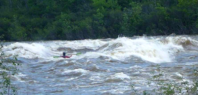
During my July 3rd outing, the flow seemed to be similar but lower to an earlier outing that I had this year. The basin that the water was flowing into was a good chunk lower. This lower basin level had the waves behaving in a more hole-ish way, and the waves were much more stationary. The eddy service was not very good, and if one was going to catch that top wave then it would require that one either do a short carry over of a ledge on river-left or a bit of a portage on the right. I was certainty not going to go into that top wave while out there alone; even if in reality it was smaller than it appears in the picture above. I sort of tried to catch the second wave, but had no success.....this time.

July 3rd

During my July 5th outing, the eddy service on river-left was very generous, but the wave (only one now) was not quite so stellar.  The main part of the wave was fairly steep and I had difficulties keeping my bow from pearling as seen in the video below. I started to get better rides later, but still nothing great. A better playboater than I with a shorter boat should of gotten something fairly decent out of it.

July 5th

Getting the Level Right: I don't really have an answer for that yet. If one walks a bit down river from the river-left put-in (nr. Rue St. Louis and Rue Paquin) and heads out on a rocky point they can get a view of the scene from a distance:
July 8th: too low

Further down river, and below Lower Farmers, there is a rock(s?), around 50m above Alonzo Wright Bridge and on river-right, that might work as a visual gauge. The picture below was taken on July 8th when Upper Farmers was for the most part too low. If the top part of the rock is buried.......... If the whole rock is buried................. Something to monitor anyhow.

Alonzo Wright Bridge Rock

Above the Wave Train:

In the rapids above these waves there are some reasonable possibilities for some short creekish type runs during lower water events; keeping in mind that this is a dry river bed for much of the year as water is diverted into the adjacent hydro station. The river is quite channelized at the top and there are multiple lines one could take over this steepest section.

Spliced images from a couple of years ago


I once went here when the river bed was in that dry state to have a look around for among other things potential hazards. The only real man-made hazard was a piece of track from the railway that went across the top of the weir. This piece of track around 20 feet long had come off the weir and was broached up against a boulder. It could of acted like a strainer if one was upside down in that section. It was quite the struggle to wrestle that unit to a safer place.


I did a couple of runs (mostly different lines) on the river right side of these rapids back in October of 2014. The video below only captures the first run, and during that run I take out half ways down to go scout the river-leftish scene from an islandmore to the center of the river. 


Wednesday, 31 May 2017

Upper Farmers Rapids, Gatineau River: May 28, 2017

So I had a good outing exploring the waves at the bottom of (Upper) Farmers Rapids this past Sunday. The three primary waves there are part of a wave train, and they are not the most stable of waves but they were good!


The water level was quite high during my outing, and I would roughly estimate that the flows only reach this level 10 days or less most years. I paddled out to these waves earlier this year during higher flows and things were mostly washed out. During a previous year I was here at what would of been slightly lower levels, and those two top waves were better defined while the third wave wasn't really happening at all.

 
Upper Farmers Rapids, Gatineau River from Dave Howlett on Vimeo.

The paddle out to the waves from the shore is a challenge from both sides of the river. The river-right side is easier, but attaining the eddy to launch from is quite a struggle. This could be greatly mitigated with a bit of bush cutting during the dry season. The top wave is pretty much split into two waves due to a ridge-like feature that is there. That ridge would make it very difficult to go from surfer's-right to surfer's-left side, and it is surfer's-left that looks more interesting. I only once launched into the current from river-right, and while trying to catch that top wave I clumsily flipped and never got to feel what it was all about. Next time!

For accessing the bottom of these rapids I unloaded by boat and gear across the street and ~30m North from Rue Paquin. There is a rough spot there to pull off this busy road:


From this boat drop off site follow a short trail that leads straight away from the road, and then turn right after descending a steep but short hill. Watch out for glass! You will soon hit water and from here you can paddle through the bushes. After hitting the open-river, follow the river-left bank up to the waves; you will be crossing over the hydro-plants trail-race along the way.

If parking and playing then it is likely best to park along one of the neighboring streets. Alternatively one can run the river down to Alonzo Wright Bridge, but beware of the hazards down at Lower Farmers. If paddling this lower part then you might want to check out my earlier post:   http://howlinglab.blogspot.ca/2013/06/farmers-rapids-and-lower-gatineau-river.html