Tuesday 11 July 2017

Upper Farmers Rapids: What a difference two days makes!

Last week I went out to Upper Farmers Rapids (Gatineau River) on July 3rd and 5th, and found very different levels.

July 3rd
July 5th

During my July 3rd outing, the flow seemed to be similar but lower to an earlier outing that I had this year. The basin that the water was flowing into was a good chunk lower. This lower basin level had the waves behaving in a more hole-ish way, and the waves were much more stationary. The eddy service was not very good, and if one was going to catch that top wave then it would require that one either do a short carry over of a ledge on river-left or a bit of a portage on the right. I was certainty not going to go into that top wave while out there alone; even if in reality it was smaller than it appears in the picture above. I sort of tried to catch the second wave, but had no success.....this time.

July 3rd

During my July 5th outing, the eddy service on river-left was very generous, but the wave (only one now) was not quite so stellar.  The main part of the wave was fairly steep and I had difficulties keeping my bow from pearling as seen in the video below. I started to get better rides later, but still nothing great. A better playboater than I with a shorter boat should of gotten something fairly decent out of it.

July 5th

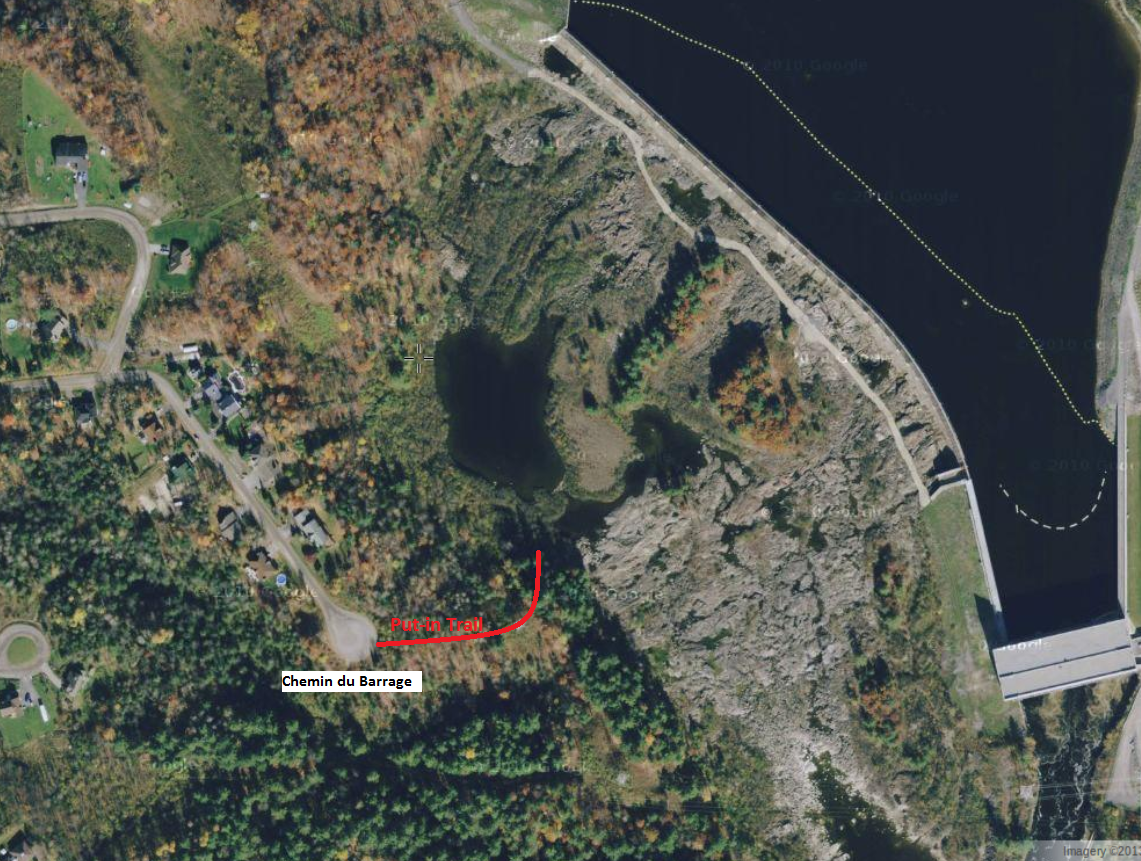
Getting the Level Right: I don't really have an answer for that yet. If one walks a bit down river from the river-left put-in (nr. Rue St. Louis and Rue Paquin) and heads out on a rocky point they can get a view of the scene from a distance:
July 8th: too low

Further down river, and below Lower Farmers, there is a rock(s?), around 50m above Alonzo Wright Bridge and on river-right, that might work as a visual gauge. The picture below was taken on July 8th when Upper Farmers was for the most part too low. If the top part of the rock is buried.......... If the whole rock is buried................. Something to monitor anyhow.

Alonzo Wright Bridge Rock

Above the Wave Train:

In the rapids above these waves there are some reasonable possibilities for some short creekish type runs during lower water events; keeping in mind that this is a dry river bed for much of the year as water is diverted into the adjacent hydro station. The river is quite channelized at the top and there are multiple lines one could take over this steepest section.

Spliced images from a couple of years ago


I once went here when the river bed was in that dry state to have a look around for among other things potential hazards. The only real man-made hazard was a piece of track from the railway that went across the top of the weir. This piece of track around 20 feet long had come off the weir and was broached up against a boulder. It could of acted like a strainer if one was upside down in that section. It was quite the struggle to wrestle that unit to a safer place.


I did a couple of runs (mostly different lines) on the river right side of these rapids back in October of 2014. The video below only captures the first run, and during that run I take out half ways down to go scout the river-leftish scene from an islandmore to the center of the river. 


Wednesday 31 May 2017

Upper Farmers Rapids, Gatineau River: May 28, 2017

So I had a good outing exploring the waves at the bottom of (Upper) Farmers Rapids this past Sunday. The three primary waves there are part of a wave train, and they are not the most stable of waves but they were good!


The water level was quite high during my outing, and I would roughly estimate that the flows only reach this level 10 days or less most years. I paddled out to these waves earlier this year during higher flows and things were mostly washed out. During a previous year I was here at what would of been slightly lower levels, and those two top waves were better defined while the third wave wasn't really happening at all.

 
Upper Farmers Rapids, Gatineau River from Dave Howlett on Vimeo.

The paddle out to the waves from the shore is a challenge from both sides of the river. The river-right side is easier, but attaining the eddy to launch from is quite a struggle. This could be greatly mitigated with a bit of bush cutting during the dry season. The top wave is pretty much split into two waves due to a ridge-like feature that is there. That ridge would make it very difficult to go from surfer's-right to surfer's-left side, and it is surfer's-left that looks more interesting. I only once launched into the current from river-right, and while trying to catch that top wave I clumsily flipped and never got to feel what it was all about. Next time!

For accessing the bottom of these rapids I unloaded by boat and gear across the street and ~30m North from Rue Paquin. There is a rough spot there to pull off this busy road:


From this boat drop off site follow a short trail that leads straight away from the road, and then turn right after descending a steep but short hill. Watch out for glass! You will soon hit water and from here you can paddle through the bushes. After hitting the open-river, follow the river-left bank up to the waves; you will be crossing over the hydro-plants trail-race along the way.

If parking and playing then it is likely best to park along one of the neighboring streets. Alternatively one can run the river down to Alonzo Wright Bridge, but beware of the hazards down at Lower Farmers. If paddling this lower part then you might want to check out my earlier post:   http://howlinglab.blogspot.ca/2013/06/farmers-rapids-and-lower-gatineau-river.html


Saturday 23 May 2015

Riviere Petite Nation - Cheneville Section


Chutes Lockbow

Posting about a short exploratory paddle and scout that I did three years ago near the town of Cheneville in Quebec. This paddle went down on April 29th, a date when the water on the Petite is usually quite high. In 2012 though Spring had come quite early, and flows in the region were well below average for that time of year. The river was flowing at 23 CMS at the gauge not far downstream from this section during my paddle and that is what is shown in the video below.

Riviere Petite Nation - Cheneville Section: April 29, 2012 from Dave Howlett on Vimeo.


A few weeks earlier I had been in the area and scouted out these drops. The river was flowing at ~43? CMS that day, and the still pictures on this post come from that day.


Putin waves below Chemin de la Presquile bridge: There is ~1.5 km of flatwater after this and one can potentially avoid that and find a alternative putin above the next drop (Chutes a Pontbrin).


Chutes a Pontbrin: I portaged around the top of this drop during my run as I was paddling solo and combined with the reset of the rapids it was quite a long one. It did look quite runnable though. Class 3+/4??


Below Chutes a Pontbrin


Lower Pontbrin


Lower Pontbrin: At the bottom of this there is reasonable chance for some play. Then there is a small pond and when the river picks up again it is a pleasent flow along swifts and some class 1 until the Chutes Lockbow.


Chutes Lockbow: I certainly walked this one. This slide has kind of two different angles of flow to it instead of just one primary one. Until it has been run I will call this one a class 5/5+


Below Chutes Lockbow: When I paddled this (at lower levels) there was a bad and well hidden strainer on river-right just above the bend. The strainer was a very large plank of wood and it may still be there.

Friday 22 May 2015

Riviere Petite Nation - Ripon Section

Posting about a short paddle that I did three years ago now. Back in the day I had been planning on scouting this section of river based upon seeing some gradient on the topo maps. Then I stumbled across a report from an earlier trip that caught me by surpise as I had never heard of a run here and it is only an hour away from my home base in Ottawa. Here is that qcrivers report in French and it inludes a map.

At the start of my video below it claims that the date of the paddle was Aug. 4th , but after uploading the video I discovered that this is likely wrong. I am now pretty certain that this paddle happened on June 17th, 2012. The flow at the nearby gauge was 15.5 CMS that day. The two waterfalls along this section both looked fairly undoable. But???


Riviere Petite Nation (Ripon Section): June17 , 2012 from Dave Howlett on Vimeo.

Tuesday 4 June 2013

Farmer's Rapids and the Lower Gatineau RIver

With the high water this Spring I've spent a bit of time sniffing out a potential new paddling location near Ottawa. Just 10 km from Parliament Hill (less than half the distance it is to Scotiabank Place), Farmer's Rapids is in a hidden away location, and what remains of it is next to a hydro generation station. That station will use 100% of the falling water during normal summer flows, but when there is excess water then that water flows over whats left of the old river bed. Flows of  5,000+ cfs can frequently be found falling down a river bed that drops 10 metres or more over ~300 metres.


The hydro station's head is listed as 20.1 metres. I'm estimating that the drop directly at the weir is no more than 10m. After the weir the water drops 2-3m more into what I'm going to call Farmer's Pools. These pools allow for good access across the top of the multiple channels that follow. The pools can be seen below during a dry period and they are easily accessed from the end of Chemin du Barrage (a residential street; please drive easy along here). From the end of the road it is an easy hike down to the river-side. The first ~100m is along a good trail that takes one to and under a hydro tower. After that tower, turn to the left and head down the hill.


The video below begins by showing the put-in and the general conditions around the pools. Yes, there is a lot of weedish bush growing up in the water in places. The upper top right of the rapids from the weir down is currently a write-off due to this growth. After paddling across the pools I ended up scouting the drops below from a mid-river island. Before arriving at the river that day, I had been hoping to see a good line through the ledges below so that I could paddle it, but this proved difficult. The river was running a bit higher than during my previous outing, I was already a little bit injured, and I was padding solo. The potential holes tend to look much bigger to me when I actually have my boat with me. Thus, I retreated to my put-in location and then portaged the top meatier part of the rapids. After my portage, I still found myself running a bit of a sneak line around some of the heavier stuff. By the time I got out into the main current there wasn't much left to it. The lower part seemed a bit washed out at this level. I'm fairly optimistic that one could find good stuff in here at much reduced flows.


After Farmer's I ran the rest of what I'll call the Lower Gatineau. This took me by the smallish but nice looking waves at 'Poutine Bend' (there is a popular poutine restaurant on river-left here). After that I came to the rapids that are above Alonzo-Wright Bridge. Today these rapids are often referred to as Farmer's Rapids, but they are not the main Farmer's Rapids. There are a lot of serious holes on the left 3/4 of these rapids and I intentionally kept 20-30 feet off the far right shore. There is some opportunity to play along here; I was a bit too late in attempting to catch one great looking wave on the fly. Next time! Along with the very serious holes through here there are stories of concrete with rebar sticking out of it on the rivers bottom. Stay right!! One can scout this rapid fairly easily from both banks. There is a convenient take-out on the downstream side of the bridge on river-left. Or use the Timmies parking lot above the bridge.

Back up to Farmer's Rapids: Immediately after the base of the weir one generally finds the worse of the weed problems, and I did notice some man-made stuff along the river bed. But on the left side of the river there is at least one channel that appears to have a clean line down it. From the pool found in the next photo one should be able to find a nice line down.


The following video shows the rapids from a couple of other angles on a sunnier day. It also shows   at the end the little bit that is left of Chelsea Rapids which are ~1 km above Farmer's.


With the high flows this June, the Lower Gatineau may make for some interesting after work paddling/exploring (without all the driving). Perhaps we can regain a chunk of this river for recreational purposes.

 Link to photo album.